


Current Outlook

University of Florida officials are actively monitoring Tropical Storm Mindy. Here’s what we know today: Mindy is expected to produce heavy rainfall from the Florida Panhandle into southern portions of Georgia and South Carolina through Thursday morning. This rainfall may produce isolated to scattered flash, urban and small stream flooding. Tropical storm warnings have been […]
University of Florida officials are actively monitoring Tropical Storm Fred. Here’s what we know today: Tropical Storm Fred has the potential to bring storm surge and heavy rains to the Panhandle and Big Bend today. Fred’s maximum sustained winds are near 60 mph. Tropical storm conditions are occurring in the warning areas and will spread […]
University of Florida officials are actively monitoring Tropical Storm Fred and Tropical Storm Grace. Here’s what we know today: Fred regained tropical storm status with maximum winds of approximately 40 mph. The center of the storm is forecast to make landfall in the western Panhandle on Monday afternoon or Monday night. Today through Tuesday, heavy […]
University of Florida officials are actively monitoring Tropical Wave Fred and Tropical Storm Grace. Here’s what we know today: Fred has degenerated into an open wave due to shear and land interaction. These changes have reduced anticipated wind and rain impacts for the Florida peninsula. No warnings or watches are currently in place for Florida. […]

Access time sensitive safety information through the UF Alert System.

This app features updates, radar maps, and alerts from the Florida Public Radio Emergency Network.
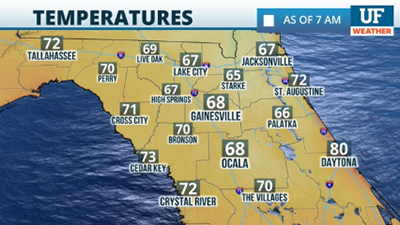
The UF Weather Center offers up-to-date news, forecasts, radar maps, and can be found here.

A fully stocked disaster supply kit can be essential during hurricane season. Find out more.
University of Florida
Gainesville, FL 32611
UF Operator: (352) 392-3261