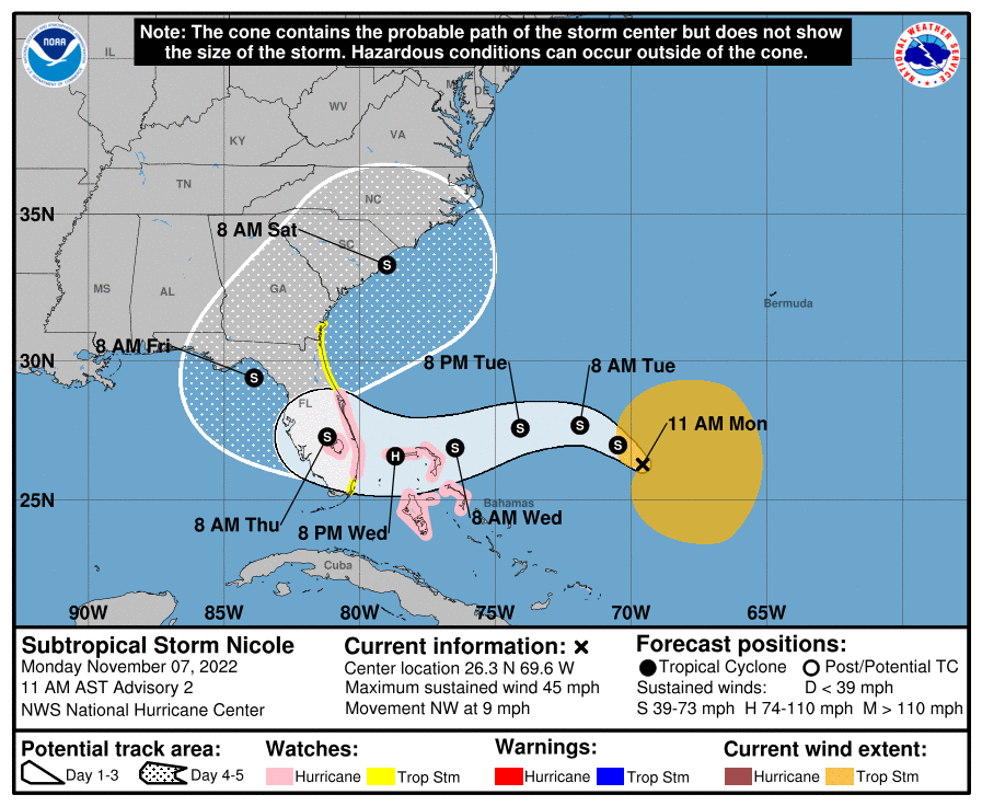
University of Florida officials are actively monitoring Subtropical Storm Nicole. While much remains unknown about the storm’s path, here is what we know today:
The National Hurricane Center issued a Hurricane Watch for the East Coast of Florida from the Volusia-Brevard county line to Hallandale Beach and for Lake Okeechobee. Additionally, a Tropical Storm Watch has been issued for the majority of the East Coast of Florida.
A Tropical Storm Watch means tropical storm conditions are possible within 48 hours, while a Hurricane Watch means hurricane conditions are possible. A Hurricane Watch is typically issued 48 hours before the anticipated first occurrence of tropical storm-force winds, conditions that make outside preparations difficult or dangerous, according to the National Hurricane Center.
As of the 11 a.m. advisory, the storm was expected to slow its forward movement, which would lead to it approaching the east coast of Florida by Wednesday night. Subtropical Storm Nicole expected to strengthen during the next few days and reach hurricane intensity by Wednesday or Wednesday night.
The National Hurricane Center believes hurricane conditions are possible within the watch area in Florida by Wednesday night and possible tropical storm conditions by Tuesday night. Nicole could also bring a maximum of 6 inches of rain to the Florida peninsula, with most of the rainfall affecting coastal counties.
UF units should continue to monitor forecasts and be prepared to follow guidance from local officials.
No tropical storm warnings or watches are currently in place for Alachua County and no operational changes are anticipated for the UF campus in Gainesville. We will continue to monitor and update the UF community on expected impacts or schedule changes as information becomes available.
For additional information, please visit National Hurricane Center.
Additional information:
Here’s how to prepare for hurricane season
