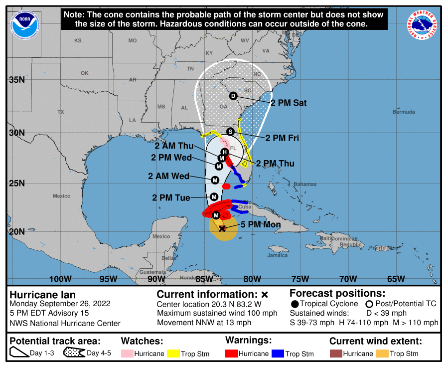
University of Florida officials are actively monitoring Hurricane Ian. While much remains unknown about the storm’s exact path, here is what we know today:
During the 5 p.m., advisory, the National Hurricane Center issued hurricane and storm surge warnings for Pinellas County and coastal Hillsborough, Manatee, and Sarasota counties.
A hurricane warning means the National Hurricane Center believes hurricane-force winds are possible in those areas within the next 36 hours.
Additional tropical storm and storm surge watches and warnings have been issued throughout parts of Central, North and Southwest Florida.
The National Hurricane Center believes there is a “danger of life-threatening storm surge along much of the Florida west coast where a storm surge warning has been issued, with the highest risk from Fort Myers to the Tampa Bay region.”
UF units should monitor forecasts and be prepared to follow guidance from local officials. The UF Research and Academic Center at Lake Nona has canceled classes and closed for business from Wednesday through Friday.
Heavy rainfall will spread to central and northern Florida on Wednesday into Thursday, potentially causing flash, urban and small stream flooding.
Though Ian was a Category 2 storm as of Monday’s 5 p.m. advisory, it is still expected to strengthen in the next 24 hours.
No operational have been announced for the UF campus in Gainesville as of this message. We will continue to monitor and update the UF community on expected impacts as information becomes available.
Regularly check https://www.ufl.edu/ for updates.
For additional information, please visit National Hurricane Center.
Additional information:
Here’s how to prepare for hurricane season
Pre-storm preparation for students in UF housing
UF/IFAS Disaster Preparation & Recovery
This story was posted at 6:53 p.m. on Monday, Sept. 26.
